Shared knowledge is key to the advancement of research, as it helps to screen different methodologies, improve technologies, and to expand mental maps leading to innovative solutions. The evaluation of the technologies and methodologies used in research by the scientific community will be of great utility to people tomorrow, rather like the comments on Internet forums about a service or product, but on a bigger scale.
We live in the golden age of satellite telemetry, which allows one to record locations remotely and then make subsequent shipments to them. The technology that allows us to move around the world without asking for directions, or buying maps, but rather just connecting our mobile GPS, is the same technology that science is using to study wildlife: geolocation. The market offers a multitude of models, and ascertaining which are the most effective is essential to those who study wildlife.
There is no one better than the users of these devices themselves to assess their capacity to identify the movements of wildlife. Carlos Rouco, a researcher in the Department of Botany, Ecology and Physiology at the University of Cordoba, has participated in an international study in which the operation of GPS collars on terrestrial fauna is analysed by combining data from more than 3,000 devices deployed on 62 species studied in 167 projects worldwide.
The prevailing conclusion of the study is that the main limitation of these devices is, typically, their battery life. Although the functioning of these devices has improved over time, GPS systems consume a lot of energy, and dead batteries are the main cause of them not completing their missions. The second most important factor affecting the performance of GPS collars was environmental conditions, which influence the quantity and quality of the data recorded, this being the conclusion reached after comparing the number of locations each device was expected to record with the final results.
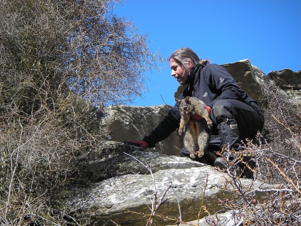
The functioning of GPS collars on New Zealand hairy-tailed possums (Brushtail possums).
Ecologist Dr Carlos Rouco is one of the researchers who tested the operation of GPS collars. During his postdoctoral stay at Landcare Research in New Zealand, Rouco used these devices for 5 years on Australian opossum populations in two different areas of New Zealand. The devices were used to determine the habitats of the Australian opossum, considered a pest in New Zealand, to be able to carry out more efficient population control. With this study an efficiency rate of 58% was achieved on the GPS devices in one of the areas (from 89,000 locations forecast, 51,000 were determined) and 71% in the other area.
To fully optimise the batteries, the main problem that most users encounter, DrRouco programmed the location readings hourly at night, as during the day the possums remain in their burrows. Subsequently, the researcher traced the opossums' locations via radio-tracking (VHF system) to locate and trap animals wearing collars and download the data from the GPS devices.
These devices are used to verify the movements of this troublesome species and to transfer the data to institutions responsible for controlling their numbers in New Zealand. Today they have become a symbol of shared knowledge and ties forged between researchers around the world
Hofman MPG, Hayward MW, Heim M, Marchand P, Rolandsen CM, et al. (2019) Right on track? Performance of satellite telemetry in terrestrial wildlife research. PLOS ONE 14(5): e0216223. https://doi.org/10.1371/journal.pone.0216223


